Equal Discharge Increment (EDI)
UPDATE
Equal Discharge Increment calculations are now available in QRev v4.x . The USGS does not currently plan to continue development on the EDI Matlab program.
1The use of trade, product, or firm names is for descriptive purposes only and does not imply endorsement by the U.S. Government.
Versions
USGS Software Users Rights Notice
Do Not Use as of 1/27/2011
|
Version
|
Status
|
Changes and Known Issues
|
| 3.32_32 3.32_64 |
Recommended | - No code changes - Requires Matlab Runtime Libraries Version 9.0, either 32-bit version or 64-bit version depending on which version of EDI you download. - Compiled with Matlab 2015b. |
| 3.31_32 3.31_64 |
Allowed | - No code changes - Requires Matlab Runtime Libraries Version 8.5, either 32-bit version or 64-bit version depending on which version of EDI you download. - Compiled with Matlab 2015a. |
| 3.30 | Allowed | - Mean velocity changed from using only 1 ensemble to using the average of 5 ensembleson both sides of the target ensemble. - Requires Matlab Runtime Libraries Version 7.17, 32-bit version (even on 64-bit operating systems) - Compiled with Matlab version 2012a. |
| 3.21 | Allowed | - Fixed bugs in new reader for ASCII output. - Requires Matlab Runtime Libraries Version 7.17, 32-bit version (even on 64-bit operating systems) - Compiled with Matlab version 2012a. |
| 3.2 | Do Not Use as of 8/31/2012 | - Fixed bug associated with reporting negative lat/lon. Negative lat/lons were reported incorrectly in the user interface. - New reader for ASCII output that is faster reading ASCII files from WinRiver II. - Requires Matlab Runtime Libraries Version 7.17, 32-bit version (even on 64-bit operating systems) - Compiled with Matlab version 2012a |
| 3.11 | Do Not Use as of 8/30/2012 | - Requires Matlab Runtime Libraries Version 7.17, 32-bit version (even on 64-bit operating systems) - Compiled with Matlab version 2012a - Negative lat/lon reported incorrectlys in user interface. |
| 3.1 | Do Not Use as of 8/30/2012 | - Fixed bug in start distance for RiverSurveyor Live using ft as units. |
| 3.00 | Do Not Use as of 8/29/2011 | - Added support for RiverSurveyor Live 1.5 or later - Added latitude and longitude output to GUI - Moved some code from pbCompute to pbOpen - Increase output resolution for SI units |
| 2.20 | Do Not Use as of 1/27/2011 | - Fixed code work with negative discharges. |
| 2.1 | Do Not Use as of 1/29/2008 | - Improved user interface when changing default percentages |
| 2.00 | Do Not Use as of 9/24/2008 | - Reformatted source code 9/23/2008 - Added version number to GUI - Added units display in GUI - Added reading file display in GUI |
| 1.00 | Do Not Use as of 9/23/2008 | - INITIAL RELEASE |
Background
Equal-discharge-increment method (EDI) samples are obtained from the centroids of equal-discharge increments across the cross section. This method requires some knowledge of the distribution of streamflow in the cross section, based on a long period of discharge record or on a discharge measurement made immediately prior to selecting sampling verticals. If this information can be obtained (such as with an ADCP), the EDI method can save time and labor; compared to the equal-width increment method. This is especially true on the larger streams, because fewer verticals are required (Hubbell and others, 1956) (Edwards and Glysson,1999).
Purpose and Scope
A discharge measurement made with an ADCP immediately prior to the collection of EDI samples can be used to identify the location, depth, and mean velocity for each EDI sample. To improve the accuracy and efficiency of using ADCP discharge measurements for EDI sampling a program was written in Matlab to read data from TRDI WinRiver II and SonTek/YSI RiverSurveyor Live ADCP software and perform the necessary computations. EDI is compiled with the Matlab compiler to allow users who do not have Matlab available to them to run the program.
Data Input
The EDI program supports all TRDI ADCPs compatible with the moving-boat discharge measurement software WinRiver II and SonTek/YSI RiverSurveyor ADCPs compatible with the moving-boat discharge measurement software RiverSurveyor Live. After collecting the required transects that comprise a valid discharge measurement the user selects a representative transect to process with the EDI program. If data were collected with WinRiver II, an ASCII output file using the Classic format must be created and used as the input file for the EDI program. If RiverSurveyor Live was used to collect the data, a Matlab output file needs to be created and used as the input file for the EDI program.
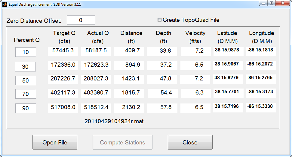
Figure 1. EDI User Interface
Discussion of Computations
The EDI program does not recomputed the measured discharge separate from the ADCP software, but rather uses the discharge elements computed by the ADCP software and stored in the files discussed in the "Data Input" section. The EDI program interface allows the user to change the default increments of 10, 30, 50, 70, and 90 percent of the discharge to any desired flow percentage between 0 and 100 (see Figure 1). The location of the sample is determined by finding the first ensemble (referred to as the target ensemble) with a cumulative discharge that exceeds the target discharge. The target discharge is computed as the Target Percentage multiplied by the Total Discharge obtained from the selected transect. Both the target discharge and measured cumulative discharge to the target ensemble are displayed in the user interface (Figure 1). The distance displayed in the user interface is from the starting bank of the selected transect and is computed as the Distance Made Good (a straight-line distance from the starting location) to the target ensemble location plus the starting edge distance and a user provided zero distance offset. Therefore, it is important that the transect traverse the channel in a straight line.
The depth displayed is computed as the simple mean of the beam depths for the target ensemble. The velocity displayed is the magnitude of the mean velocity of the measured part of the velocity profile for the target ensemble. No accounting for the unmeasured part of the velocity profile is included. If GPS data are available in the ADCP files, the longitude and latitude in degrees, minutes, and decimal minutes are displayed for each target sample-location. These data may be used with navigation software and devices to assist in navigating to and holding the boat on the desired locations. In addition, there is an option (Figure 1) to create a file compatible with Delorme TopoQuad software. The file is named "tqlatlon.txt" and contains the information to plot a yellow dot for each sampling location in the TopoQuad display.
Limitations
- Only moving-boat measurements are supported. Mid-section type measurements made with ADCPs are not supported.
- The mean velocity is based only on a single ensemble and does not consider the unmeasured top and bottom parts of the profile.<\li>
1The use of trade, product, or firm names is for descriptive purposes only and does not imply endorsement by the U.S. Government.
How to Download the Software
The latest version of EDI can be downloaded by clicking on the version number in the table above. In order to provide support for extrap and to provide an efficient means to communicate with users and allow users an efficient and organized means of providing suggestions and comments, you are encouraged to register for the OSW Hydroacoustic Forum. In the forum you will find an "EDI" board under Hydroacoustics Software. Open the EDI board and click "Notify" to automatically receive emails on any bug fixes or issues identified with extrap. This is the only way of being automatically notified if there has been an identified problem or if a new version has been released.
Register for access to OSW Hydroacoustics Forums
Installation Instructions
- Install the appropriate Matlab Component Runtime libary, if necessary. For instructions on how to determine if you have the needed library and/or to install the library see Matlab Component Runtime Library Download and Installation
- Download the EDI executable from above.
- Select a directory and store the EDI_3_30*.exe file. This file can be in any directory where the user has read/write permission.
- Run the program by double-clicking on EDI_3_30*.exe in Windows Explorer or My Computer. You may wish to create a shortcut to EDI_3_30*.exe in a convenient location in the Start Menu or on the Desktop.
Operational Instructions
- Use the appropriate manufacturer's softwater to identify and select a transect collected with an ADCP and process the transect to a TRDI compatible Classic ASCII output file or a SonTek/YSI RiverSurveyor Live Matlab output file.
- If you created a shortcut to EDI_3_30*.exe during the installation, you can run the program using the shortcut. Otherwise you can run the program by double-clicking on EDI.exe in Windows Explorer or My Computer. Note: It may take more time than expected for the EDI GUI to appear, particularly the first time it is run. Please be patient.
- Click on "Open File" and navigate and open the desired *t.000 or *ASC.txt or *.mat file depending on the type of ADCP and software used.
- A message at the bottom of the table will notify you that file is being read. After the file has finished loading, the name of the file will appear below the EDI table. Reading the file can be a slow process, be patient.
- If you collected GPS data along with the ADCP data and you use DeLorme TopoQuads to assist in navigating to the sample locations, clicking the Create TopoQuads check box will create a TopoQuad compatible file that when loaded into TopoQuads will mark each computed sample location. You will be prompted to name this file after you click on Compute Stations. The file will be located in the same directory as the input file you processed.
- The standard set of discharge percentages are available by default but they can be edited and changed by the user.
- Enter the appropriate Zero Distance Offset. If the distance reference is from the edge of water then the Zero Distance Offset is set to zero. However, if referencing from a target on the bank then the distance from the target to edge of water should be entered.
- Confirm the default settings or modify the five discharge percentages and then click "Compute Stations". The table will populate the with the appropriate data.
- The discharge percentage settings can be changed and the stations can be recomputed without having to reload the file.
NOTE: If the cross section was from left to right, distances are from the left bank but if the cross section was from right to left, distances are from the right bank.
References
Edward, T.K. and Glysson, G.D., 1999, Field methods for measurement of fluvial sediment, U.S. Geological Survey Techniques of Water-Resources Investigations, Book 3, Chapter C2, 89 p.
Hubbell, D.W., and others, 1956, Progress report no. 1, Investigations of some sedimentation characteristics of a sand-bed stream: U.S. Geological Survey Open-File Report, 78 p.